Article IV Overlay Districts
Source: zoning-ordinance-2026-03-11.pdf, pages 74-101.
Section 400 Establishment of Overlay Districts.
The following overlay districts are hereby established:
- Wetlands Conservation District
- Floodplain District
- Steep Slope District
- Airport Protection District
- Historic District
- Landfill Reclamation District
- Riverbank Protection District
In the areas of the City which are included in an overlay district, the regulations of the overlay district shall apply in addition to the regulations of the applicable use district. Where regulations in a use district and an overlay district conflict, the regulation of the most restrictive district shall apply.
Section 401 Wetlands Conservation District.
401.1 Purposes.
The purposes of the Wetlands Conservation District are to:
- A. Preserve wetlands, which provide flood protection, recharge groundwater supply, augment stream flow during dry periods, provide wildlife habitat, and enhance water quality; and which are important for such other reasons as those cited in RSA 482-A:1.
- B. Prevent the development of structures and land uses on wetlands, which would contribute to the pollution of surface or ground water, disrupt wetland ecosystems, and damage property due to flooding.
- C. Prevent unnecessary or excessive expenses to the City of Lebanon for essential services and utilities because of the incompatible use of wetlands.
- D. Allow those uses that can be appropriately and safely located in wetlands, following best management practices recognized by the State of New Hampshire.
- E. Protect wetland-dependent wildlife habitat for native flora & fauna.
- F. Enhance protection for the high quality wetlands and located in the City of Lebanon, which require naturally vegetated buffers for the integrity of their ecosystems.
- G. Preserve and enhance scenic and educational values associated with the wetlands in the City of Lebanon.
- H. Achieve a higher level of protection in wetlands categorized as of high or very high function and value, by prohibiting inappropriate uses.
401.2 Description of Wetlands Conservation District.
The Wetlands Conservation District includes the following:
- A. All areas in the City that are inundated or saturated by surface water or groundwater at a frequency and duration sufficient to support, and that under normal conditions do support, a prevalence of vegetation typically adapted for life in saturated soil conditions as set forth in RSA 482-A and 674:55.
- B. A horizontal buffer of 100 feet to all wetlands of High or Very High Value according to Natural Lebanon: Results of the Phase II Natural Resource Inventory of the City of Lebanon, NH (June 2010), and further depicted in the Lebanon Wetland Overlay District map adopted March 12, 2013.
- C. Buffers are applied irrespective of lot lines and municipal boundaries. When a wetland is located solely on one side of a street or public street, buffer restrictions shall not apply to any properties on the opposite side of the street or public street.
401.3 Boundary Disputes.
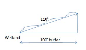
In a dispute about the boundary of the Wetlands Conservation District, the edge of a wetland, as defined by RSA 482-A and as required by RSA 674:55, shall be determined by a certified wetland scientist using field methods prescribed by the Army Corps of Engineers Wetland Delineation Manual (January 1987) and the Regional Supplement to the Corps of Engineers Wetland Delineation Manual: Northcentral and Northeast Region (January 2012, as amended). Where applicable, the edge of the buffer shall be computed as a horizontal distance from the edge of the wetland, as determined above. If the land is sloped, the measurement along the sloped ground is not applicable (see diagram). The City may retain an independent certified wetland scientist to map the area in question and require the applicant to pay the cost thereof.
401.4 Permitted Uses.
The following table identifies the uses that are permissible within the Wetland Conservation District, provided such uses do not involve a structure (except as expressly referenced) and do not alter the surface configuration of the land by the addition of fill, by excavation or dredging, by the construction of dams, or by any other process which would alter the ground or surface water level of any portion of the wetlands, including but not limited to channeling, draining or other means:
| Wetland | Wetland (High & Very High Value) | Wetland buffer (100' to Very High & High Value wetland) |
|---|---|---|
| A, B, C, D, E, F, G, I | C, E, F, G | A*, B, C, D, E, F, G, H, I |
- A. Forestry, tree farming; and agriculture, including grazing, hay production, truck gardening, and silage production; provided the applicant demonstrates that such uses adhere to best management practices (see Appendix A) and will not cause or contribute to soil erosion, and that such use is not detrimental to surface water or ground water because of the use of pesticides, fertilizers, herbicides, toxic or other hazardous substances.
*See section 401.6.C Special Provisions for additional requirements of these permitted uses within section 401.2.B Wetland Buffers.
- B. Wells for water supplies.
- C. Wildlife habitat development and management.
- D. Low-impact recreational uses such as pedestrian trails.
- E. Open space as permitted by the City of Lebanon Subdivision Regulations and other sections of this Ordinance.
- F. Conservation.
- G. Wetland enhancement or restoration.
- H. Only within the wetland buffer, minor accessory structures of 130 square feet or less in which there is no storage of petroleum products, hazardous chemicals or materials.
- I. Use otherwise permitted at that site by the Zoning Ordinance and State and Federal law, provided such use does not involve a structure (except as expressly referenced), and does not alter the surface configuration of the land by the addition of fill, by excavation or dredging, by the construction of dams, or by any other process which would alter the ground or surface water level of any portion of the wetlands, including but not limited to channeling, draining or other means.
401.5 Special Exceptions.
Except for projects proposed within the High and Very High Value wetlands portion of the Wetland Conservation District, projects that qualify for a Permit by Notification, Minimum Impact Expedited Permit or any other type of Minimum Impact Permit from the State of NH Dept. of Environmental Services Wetlands Bureau shall be exempt from the requirement to obtain a special exception. However, a notification form informing of said projects shall be supplied to the Zoning Administrator.
Upon application to the Zoning Board of Adjustment, excepting the Wetland Conservation District identified as Very High or High Value wetland, a special exception may be requested to permit the erection of a structure; the construction of streets, roads, and other access ways; for pipelines, powerlines, and other transmission lines; and the construction of fences, footbridges, catwalks and docks within the Wetlands Conservation District, provided that all of the following conditions are found to exist, in lieu of the findings required by Section 801.3:
- A. The use for which the exception is sought cannot feasibly, after consideration of all alternatives, be carried out on a portion or portions of the lot which are outside the Wetlands Conservation District; and
- B. Due to the provisions of the Wetlands Conservation District, as applied to the particular characteristics, setting and environment of the property, the lot cannot reasonably be used for any of the uses permitted or allowed by special exception, without some form of special exception under this section; and
- C. The design and construction of the proposed use is consistent with the purpose and intent of Section 401.1 (A), (B) and (C) of this Ordinance, and adequate conservation measures shall be taken to mitigate the detrimental effects of the proposed use on the natural function of the wetlands. Such measures may include but are not limited to wetland restoration or enhancement, wetland preservation, or the construction and maintenance of new wetland areas adjacent to the proposed use to replace those portions of the natural wetland affected by the proposed use; and
- D. The proposed construction design of pipelines, powerlines and other transmission lines shall include provisions for restoration of the site as closely as possible to its original grade and conditions; and
- E. The proposed use shall not create a hazard to individual or public health, safety and welfare due to the loss of wetland, the contamination of ground water, or any other reason; and
- F. The project is capable of complying with all State and Federal wetlands and wetlands permitting requirements. Note: Applications for required Federal and State wetland permits need not have been applied for, but a zoning permit shall not be issued until all such permits have been granted.
- G. The project is capable of conforming to all existing best management practices, as referenced in Appendix A, and will be implemented in a way which conforms to those practices, and which complies with any other conditions imposed by the Zoning Board of Adjustment.
| Wetland | Wetland (High & Very High Value) | Wetland buffer 100' to Very High & High Value wetland) | |
|---|---|---|---|
| Structure | SE | Prohibited | SE |
| Streets/Roads/Access Ways | SE | Prohibited | SE |
| Pipelines/Powerlines/Transmission lines | SE | Prohibited | SE |
| Fences, Footbridges, | SE | Prohibited | SE (see Section 401.6) |
| Catwalk & Docks | SE | Prohibited | N/A |
401.6 Special Provisions.
- A. The Wetlands Conservation District is an Overlay District. Where the provision of this Section conflicts with those of any underlying zoning district such as the Riverbank Protection District, the more restrictive standards shall apply.
- B. Septic Tanks and Leach Fields.
- 1. No septic tank or leach field shall be constructed or enlarged to be within 75 feet of any wetland of low, medium-low or medium value, or to within 100 feet of any wetland of High or Very High Value.
- 2. Previously constructed, non-conforming septic tanks or leach fields that fall within these limits shall be replaced either in-kind or in a way that is less non-conforming, subject to State and local approval.
- C. Timber Cutting.
- 1. In areas within the Wetland Conservation District where forestry is a permitted use, timber harvesting for forest management and commercial agriculture shall leave a minimum 25-foot naturally vegetated buffer from the edge of a High or Very High Value wetland; the remainder of the associated activities and operations beyond the 25-foot buffer shall be in conformance with the most recent best management practices (see Appendix A) as cited in 401.4.A.
- 2. Even in wetland and wetland buffer areas where forestry is otherwise permitted, the cutting of timber for the purpose of converting the use of the land to uses other than forestry or agriculture shall be prohibited unless all permits necessary for that change of use have been issued. Moreover, within a 12-month period no more than 50 percent of the basal area of trees shall be cut or otherwise felled, leaving a well distributed stand of healthy trees. In areas that coincide with the Riverbank Protection District, the latter's vegetation removal rules will apply.
- D. Driveways/Roadways/Access Ways/Parking Areas, Culvert Replacements, Minor Crossings.
- 1. Pre-existing driveways, roadways, access ways or parking areas established at the time of passage and located within the buffer component of the Wetland Conservation District, shall be considered non-conforming and may be repaired or replaced.
- 2. Pre-existing culverts established at the time of passage of this ordinance and located within the buffer component of the Wetland Conservation District shall be considered non-conforming, and may be replaced either in-kind or of a larger diameter and capacity as recommended by the State Department of Environmental Services Stream Rules Env-Wt Chapter 900, as amended.
- 3. Pre-existing pipelines established at the time of passage and located within the buffer component of the Wetland Conservation District of this ordinance shall be considered non-conforming, and may be replaced either in-kind or of a larger diameter and capacity.
- 4. Minor Crossings of the Wetland Conservation District, including but not limited to foot bridges, snowmobile bridges, temporary timber harvesting crossings, boardwalks for educational or recreational purposes, and other temporary or permanent crossings that do not significantly alter wetlands or their vegetated buffers, shall be allowed by simple notification to the Zoning Administrator.
- E. The expansion of non-conforming buildings and Structures, located within the Wetland Conservation District, is regulated under Article VII, Non-Conformities, of this Ordinance, except as follows:
- 1. The addition of an open deck or porch is permitted to a maximum of twelve (12) feet, including towards the wetland.
- 2. The expansion of the non-conforming portions of existing buildings and structures located within the wetland buffer shall be allowed, provided the expansion does not encroach further towards the wetland and that expansions are less than twenty (20) percent of the existing building footprint.
- 3. The vertical expansion of existing buildings within the wetland buffer is permissible within the Wetland Conservation District.
- F. No underground chemical or fuel storage tank(s) (excluding propane) of any size shall be constructed, enlarged or replaced underground within 200 feet of a wetland.
401.7 Applications to Zoning Board of Adjustment.
- A. Appeals of Administrative Decisions: Appeals of decisions of the Building Inspector, Zoning Administrator, Planning Board or other administrative officials relative to the Wetlands Conservation District may be made to the Zoning Board of Adjustment as administrative appeals pursuant to RSA 674:33. If such an appeal is from a determination of the district boundary, the appellant, if owner of the land in question, shall submit a map produced by a certified wetland scientist depicting the wetlands boundary. After initial hearing, the Zoning Board of Adjustment may require additional mapping, if necessary, at the expense of the applicant.
- B. Environmental Impact Assessment: The Board may require the applicant to submit an environmental impact assessment when necessary to evaluate an application made under this Section. For all projects involving fill or dredge in wetlands of High or Very High Value, an environmental impact statement shall be required. The cost of this assessment shall be borne by the applicant.
- C. Notice and Hearing Procedures: Shall comply with Article VIII, Section 802 Board Procedures.
- D. Interested Parties: The Lebanon Conservation Commission is hereby determined to be an interested party to any Zoning Board of Adjustment proceeding under this section. Upon receipt of an application, the Zoning Board of Adjustment shall immediately forward a copy of the complete application to the Conservation Commission. The Conservation Commission shall receive notice of all proceedings of the Zoning Board of Adjustment, and the Zoning Board of Adjustment shall give due weight to all evidence submitted to it by the Conservation Commission.
Section 402 Floodplain District.
402.1 Description of Floodplain District.
The Floodplain District includes all special flood hazard areas designated by the Federal Emergency Management Agency (FEMA) in its “Flood Insurance Study for the County of Grafton, NH” dated February 20, 2008, together with the associated Flood Insurance Rate Maps dated February 20, 2008. Said maps are on file with the City Clerk, Planning Board and City Engineer.
402.2 Floodplain District Regulations.
Within the Floodplain District, all requirements of the Flood Damage Prevention Ordinance of June 4, 1980, City Code Chapter 74, as amended, shall be complied with.
402.3 Floodplain Official.
The Floodplain Official is responsible for administering and enforcing Section 402.2. The City Engineer will normally serve as the Floodplain Official. See City Code Chapter 74-15.
Section 403 Steep Slopes District.
403.1 Purpose.
The purpose of the Steep Slope District is to prevent development on slopes in excess of 25 percent. Development on such slopes causes soil erosion and stream sedimentation; unnecessary loss of vegetative ground cover and destruction of trees; on-site waste disposal problems; difficult street construction; and expensive street maintenance.
403.2 Description of Steep Slopes District.
The Steep Slope District includes all areas having slopes in excess of 25 percent that are located within the RL-3 District. The slope of the natural terrain shall be determinative of whether or not land is within the district. As a general guide, areas of slope in excess of 25 percent are delineated on the Steep Slopes Map prepared as part of the Lebanon Master Plan.
403.3 Permitted Uses.
No buildings, structures or parking lots shall be permitted in the Steep Slopes District. Otherwise, the following uses are permitted:
- A. Wildlife refuges, conservation areas and nature trails.
- B. Open space and outdoor recreation.
403.4 Special Exceptions.
- A. Roads and driveways may be granted special exceptions to cross the Steep Slopes District subject to the following findings by the Board of Adjustment.
- 1. The lot cannot be reasonably used without such a crossing.
- 2. The design and construction of the crossing will not cause:
- a. Soil erosion; or
- b. Stream sedimentation; or
- c. Loss of excessive vegetative cover; or
- d. Expensive public maintenance costs.
- 3. The crossing will not adversely scar a ridgeline or hillside that is a prominent visual amenity in the City.
- 4. All other requirements for special exceptions, as set for in Section 801.3 are met.
- B. Structures accessory to a use permitted by Section 403.3, such as trailside shelters.
- C. Commercial forest management and agriculture using best management practices in order to protect streams from drainage and to prevent sedimentation.
Section 404 Ridgeline District. (reserved)
Reserved.
Section 405 Scenic Corridors District. (reserved)
Reserved.
Section 406 Aquifer Protection District. (reserved)
Reserved.
Section 407 Airport Protection District.
Notwithstanding any other provision of this Ordinance, in order to provide for the safety of aircraft landing and taking off from Lebanon Municipal Airport, the following regulations shall apply:
407.1 Imaginary Surfaces for Objects Affecting Navigable Airspace.
- A. Height Limitations. No new structure shall be built, existing structure extended in height or tree allowed to grow that would penetrate the imaginary surfaces described below:
- 1. Primary surface extends 200 feet beyond each end of the runways and is longitudinally centered on the runways with a width of 500 feet for Runway 7-25 and 1,000 feet for Runway 18-36.
- 2. Approach surface to Runway 7 which is 500 feet wide at a point 200 feet from the end of the pavement and 3,500 feet wide at 10,000 feet from the end of the primary surface of the runway, an inclined plane of 34:1 slope.
- 3. Approach surface to Runway 25 which is 500 feet wide at a point 200 feet from the end of the pavement and 3,500 feet wide at 10,000 feet from the end of the primary surface of the runway, an inclined plane of 34:1 slope.
- 4. Approach surface to Runway 18 which is 1,000 feet wide at a point 200 feet from the end of the pavement and 4,000 feet wide at 10,000 feet from the end of the primary surface of the runway, an inclined plane of 50:1 slope, and for an additional 40,000 feet at which point is 16,000 feet wide, and inclined plan of 40:1 slope.
- 5. Approach surface to Runway 36 which is 1,000 feet wide at a point 200 feet from the end of the pavement and 3,500 feet wide at 10,000 feet from the end of the primary surface of the runway, an inclined plan of 34:1 slope.
- 6. Transitional surface which extends at an inclined plan of 7:1 slope from the sides of the primary surface and from the sides of the approach surfaces.
- 7. Horizontal surface which is a horizontal plane 150 feet above the established Airport elevation and the perimeter extends 10,000 feet from the center of each end of the primary surface of each runway.
- 8. Conical surface which is the surface extending outward and upward from the periphery of the horizontal surface at an inclined plane of 20:1 slope for a horizontal distance of 4,000 feet.
- B. Exceptions.
- 1. The height limitations set forth in subsection A shall not apply to any structure that has either received approval from the Federal Aviation Administration to pierce the imaginary surface, or is otherwise permitted to do so by and in accordance with Part 77 Federal Aviation Regulations.
- 2. Nothing in subsection A shall limit the height of any off-airport structure or tree to less than 30 feet above the ground upon which it is located, subject to the limitations set forth in Section 407.3.
- C. Zoning Permits. The Zoning Administrator shall consult with the Airport Manager prior to the issuance of a zoning permit for any structure located within the horizontal surfaces of the Airport described in subsection A and which does not qualify for an exception under subsection B.
407.2 References.
The above surfaces are indicated upon the current Airport Master Plan maintained by the Airport Manager and on file in his or her office. The surfaces are taken from Part 77 Federal Aviation Regulations and are based upon the ultimate development of the Airport with runways and primary surfaces as follow:
- A. Runway 7-25 paved 5,345' x 100' Primary surface 5,745' x 500'
- B. Runway 18-36 paved 5,800' x 100' Primary surface 6,200' x 1,000'
407.3 Use of Land Near Airport.
No use may be made of land within the horizontal surfaces of the Airport described in Section 407.1.A. in such manner as to create electrical interference with radio aids or communications between the Airport and aircraft; make it difficult for flyers to distinguish between Airport lights and other lights; result in glare in the eyes of flyers using the Airport; impair visibility in the vicinity of the Airport by the creation and discharge of smoke, steam, dust or other obstructions to visibility or otherwise endangering the landing, taking off or maneuvering of aircraft.
407.4 Requirements for Indication of Hazards.
Any variance granted to allow a greater height than permitted in Section 407.1 may require the owner of the property, at his or her own expense, to install, operate, and maintain thereon such markers and lights as may be required by the FAA to indicate to flyers the presence of an Airport hazard.
Section 408 Historic District.
408.1 Authority.
This section is enacted pursuant to RSA 674:46. The City of Lebanon Heritage Commission shall have the authority granted to it by RSA 674:44-a through d, et. seq., and this Ordinance.
408.2 Purposes.
The purpose of this Ordinance is to preserve the historic and cultural resources of the City of Lebanon and, particularly, the City’s structures and places of historic, architectural and community value in order to:
- A. Establish and preserve districts in the City which reflect elements of its cultural, social, economic, political, community, and architectural history;
- B. Conserve property values in such districts;
- C. Foster civic beauty;
- D. Strengthen the local economy; and,
- E. Promote the use of historic districts for the education, pleasure, and welfare of the citizens of the City.
408.3 Delineation of Historic Districts.
The areas and boundaries of the Historic Districts are shown on the Historic District Map of the City of Lebanon and made a part of this Ordinance and the Official Zoning Map of the City of Lebanon. The Historic District Map is attached hereto as Appendix C.
408.4 Certificate of Approval Required.
A Certificate of Approval shall be obtained from the Heritage Commission in the manner set forth herein prior to the commencement of any of the following activities within any Historic District:
- A. The construction of any new building;
- B. The addition to, alteration, or repair of any existing building, lot or structure which would require the issuance of a building permit pursuant to the provisions of the Lebanon Building Code, unless such addition, alteration, or repair does not, in any way, alter the exterior or appearance of such building; lot or structure.
- C. The following activities, whether or not a building permit is required for such activities:
- 1. Roofing or re-roofing if it involves a change of design, materials, or roof plane;
- 2. Siding, including new and re-siding, if it involves a change of design or materials;
- 3. Painting is applied to a previously unpainted surface;
- 4. Replacement of doors and windows if it involves changes in the material, size, location, or number of openings in the exterior or facade of a building;
- 5. Replacement or enclosure of porches, decks, and patios if it involves a change in size, location, design, or materials;
- 6. Replacement of exterior stairs, landings, and overhangs if it involves a change in size, location, design, or materials;
- 7. Construction of or alteration to fences, walls, foundations, sculptures, monument, permanent freestanding lighting, or similar humanmade features if it involves a change of location, design, or materials;
- 8. Demolition or moving of a building or accessory building.
No building permit (when applicable) shall be issued prior to the receipt of a Certificate of Approval for the above-described activities.
408.5 Activities Not Requiring Certificates of Approval.
The following activities are exempt from review by the Heritage Commission, and no Certificate of Approval shall be required:
- A. Any repairs, alterations, or improvements that do not require a building permit pursuant to the Lebanon Building Code with the exception of the activities described in Section 408.4 herein;
- B. Any repairs, alterations, or improvements to the interior of the building;
408.6 Criteria For Review.
In determining whether or not to grant a Certificate of Approval, the Heritage Commission shall keep in mind the purpose set forth in Section 408.2 herein and shall consider, among other appropriate factors, the following:
- A. The historical or architectural value of a building and its setting;
- B. In connection with additions, repair or restoration of any existing building, the compatibility of the exterior design, arrangement, texture, and materials proposed to be used in relationship to this existing building, its setting, and the Historic District as a whole; and,
- C. The size, scale, and design of proposed construction in relationship to the existing surroundings, including consideration of such factors as a building's overall height, width, street frontage, number of stories, type of roofs, facade openings (windows and doors), and architectural details.
When the Heritage Commission determines that it is necessary or advisable in order to preserve or protect historically and/or architecturally significant buildings, the Commission may require preservation and/or accurate reproduction of exterior architectural features. Preservation and/or reproduction measures shall be completed pursuant to the “Secretary of the Interior’s Standards for Rehabilitation and Guidelines for Rehabilitating Historic Buildings.”
- 1. A property shall be used for its historic purpose to be places in a new use that requires minimal change to the defining characteristics of the building and its site and environment.
- 2. The historic character of a property shall be retained and preserved. The removal of historic materials or alteration of features and spaces that characterize a property shall be avoided.
- 3. Each property shall be recognized as a physical record of its time, place, and use. Changes that create a false sense of historical development, such as adding conjectural features or architectural elements from other buildings, shall not be undertaken.
- 4. Most properties change over time; those changes that have acquired historic significance in their own right shall be retained and preserved.
- 5. Distinctive features, finishes, and construction techniques or examples of craftmanship that characterize a historic property shall be preserved.
- 6. Deteriorated historic features shall be repaired rather than replaced. Where the severity of deterioration requires replacement of a distinctive feature, the new feature shall match the old in design, color, texture, and other visual qualities and, where possible, materials. Replacement of missing features shall be substantiated by documentary, physical, or pictorial evidence.
- 7. Chemical and physical treatments, such as sandblasting, that cause damage to historic materials shall not be used. The surface cleaning of structures, if appropriate, shall be undertaken using the gentlest means possible.
- 8. Significant archeological resources affected by a project shall be protected and preserved. If such resources must be disturbed, mitigation measures shall be undertaken.
- 9. New additions, exterior alterations, or related new construction shall not destroy historic materials that characterize the property.
- 10. New addition and adjacent or related new construction shall be undertaken in such a manner that if removed in the future, the essential form and integrity of the historic property and its environment would be unimpaired.
The new work shall be differentiated from the old and shall be compatible with the massing, size, scale, and architectural features to protect the historic integrity of the property and its environment.
Applications for Certificates of Approval may be denied if such denial is required to prevent construction or development which would conflict with the stated purposes of Section 408.2 herein.
408.7 Application Procedures.
The following procedures and any rules of procedure duly adopted by the Heritage Commission shall be followed in processing applications for Certificates of Approval:
- A. Written application for Certificates of Approval shall be made no later than 12:00 noon of the 15th calendar day prior to a regularly scheduled meeting of the Heritage Commission (to include the meeting date of the Commission) on forms provided by the Zoning Administrator, and the applicant shall pay an application fee as adopted by the City Council. The application may be filed simultaneously with any other application or request for City land use permits, and the issuance of a Certificate of Approval shall not be a precondition to the issuance of any other City land use permit with the exception of a building permit, when applicable.
- B. There shall be a public hearing on all applications for Certificates of Approval. The applicant and all abutters shall receive a notice of the public hearing by certified mail, and a public notice of the hearing shall be posted in at least two public places and shall be published in a newspaper of general circulation in the City of Lebanon. Said notice shall be given not less than five days, nor more than 30 days, before the date of the hearing.
- C. At its meeting, the Commission shall review the application for completeness as specified in Section 408.8 herein. If the application is determined to be complete, then the Commission shall vote to accept the application and commence with the public hearing. If the application is not complete, then consideration of the application shall be suspended until it is complete.
- D. The Commission shall review the application using the criteria set forth in Section 408.6 herein, and then shall act to approve, approve with conditions, or disapprove the application. In reviewing the application, the Commission may request reports and recommendations regarding the feasibility of the applicant's proposal from the Planning Board, Fire Chief, Building Inspector, Health Officer, and other administrative officials who may possess information concerning the impact of the proposal on the Historic District. The Commission may also seek advice from professional, educational, cultural, or other groups or persons as may be deemed necessary for the determination of a reasonable decision.
- E. Within 45 calendar days from the filing of the application, unless the applicant agrees, in writing, to a longer review period, the Commission shall notify the applicant, in writing, of its action by means of the Certificate of Approval or Notice of Disapproval sent by certified mail. In case of disapproval, the Commission shall clearly set forth in a Notice of Disapproval the reasons for its action, with specific reference to standards contained in this Section.
- F. Simultaneously with notifying the applicant, the Commission shall file a copy of the Certificate of Approval with the Zoning Administrator and the Building Inspector. The Building Inspector shall not issue a building permit for any activity in an Historic District requiring a Certificate of Approval until receipt of said Certificate. In the case of a disapproval, the Notice of Disapproval shall be binding on the Building Inspector or other duly delegated authority and no permit shall be issued.
- G. Failure of the Commission to file said Certificate within the specified period of time shall constitute approval by the Commission.
408.8 Submittal Requirements.
All applications for a Certificate of Approval shall contain a written description of the work or activity for which approval is requested, together with plan and elevation drawings to scale and, where appropriate, photographs which, together, shall be sufficient to reasonably inform the Heritage Commission as to the type or nature of the activity applied for, the location of the activity, and the effect or impact on the exterior of the building(s) involved.
408.9 Removal or Demolition of Buildings.
No building shall be demolished or moved off its lot within any Historic District until, following a receipt of a Certificate of Approval, at least one publication of notice of such demolition or removal has been published by the owner in a newspaper of general circulation in the area in which the building and lot are located, such notice to be published not less than 30 days prior to the date of such demolition or removal.
The purpose of this provision is to further the purposes of Section 408.2 and to afford a person or organization the opportunity to acquire, or to arrange for the preservation of, such building.
Notwithstanding the above, upon application to the City Building Inspector, any building substantially damaged as a result of fire or other disaster or constituting a public safety hazard shall be exempt from the provisions of this section.
408.10 Appeal.
Any person aggrieved by a decision of the Heritage Commission shall have the right to appeal said decision to the Zoning Board of Adjustment as provided by RSA 677:17. Such appeals shall be filed with the Zoning Board of Adjustment within 20 days of the filing of the Certificate of Approval or Notice of Disapproval with the Building Inspector.
408.11 Enforcement.
The provisions of this Section 408 shall be enforced as provided by State law and pursuant to Section 903 of this Ordinance.
Section 409 Landfill Reclamation District.
409.1 Purpose.
The purpose of the Landfill Reclamation District is to encourage the reclamation and alternative secondary uses of municipally-owned land that has been used for disposing waste. Land so used for waste disposal will principally remain, indefinitely, as a waste disposal site. For instance, even though a sanitary landfill may be capped, there will be continual monitoring requirements that can last many years. At the same time, as technological advances are made, additional secondary uses can be made of a former landfill site that are compatible with monitoring objectives. The overlay district is intended to permit secondary uses of waste disposal land area that has been closed or capped, subject to approval by the City and by the New Hampshire Department of Environmental Services.
409.2 Description of Landfill Reclamation District.
The Landfill Reclamation District includes all municipally-owned land within the Heavy Industrial (IND-H) District that is designated as a waste disposal area.
409.3 Permitted Uses.
The following uses are permitted in a closed or capped waste disposal area:
- A. Outdoor recreational facility.
- B. Indoor recreational facility.
- C. Accessory uses to the secondary permitted recreational use, such as control or maintenance buildings and structures to allow food sales.
- D. Renewable energy system.
- E. Renewable generation facility as defined in NH RSA 72:73.
409.4 Special Requirements.
Prior to the issuance of a building permit, all approvals and permits from the New Hampshire Department of Environmental Services and any other applicable regulatory agency or body, including the Lebanon Planning Board, must be obtained for the proposed secondary use and for its site plans.
Section 410 Riverbank Protection District.
410.1 Purposes.
The purpose of the Riverbank Protection District is to protect the health, safety, and general welfare of the people of the City of Lebanon by protecting its water quality and natural resources and by providing reasonable regulations governing the development and use of land adjacent to its rivers, streams, and associated wetlands. More specifically, this District is intended to serve the following purposes:
- A. Protect and maintain existing and potential water supplies for use by the general public;
- B. Safeguard the ecological integrity of Lebanon's streams and rivers, including but not limited to:
- 1. minimizing erosion;
- 2. preventing siltation and turbidity;
- 3. stabilizing soils;
- 4. preventing excess nutrients and chemical pollution;
- 5. maintaining natural water temperatures;
- 6. maintaining a healthy tree canopy and understory;
- 7. preserving fish, bird and wildlife habitat; and
- 8. respecting the overall natural conditions of the Riverbank.
- C. Prevent pollution of surface water and groundwater associated with the stream and river systems;
- D. Prevent destruction or significant alteration of the natural flow of watercourses;
- E. Prevent unnecessary or excessive expenditures of municipal funds which would arise as a result of improper development of land within the Riverbank Protection District;
- F. Maintain water quantity and instream flow during low flow periods;
- G. Protect the recreational values associated with rivers, streams, and their riparian areas;
- H. Preserve the visual and scenic richness of Lebanon by protecting the aesthetic features associated with its rivers, streams, and riparian areas.
- I. Prevent the destruction of or significant changes to those riparian lands which provide flood protection and protect persons and property against the hazards of flood inundations, by assuring the continuation of the natural flow patterns of streams and other watercourses.
410.2 Authority.
This section of the Zoning Ordinance is adopted pursuant to the authority granted by RSA 483-B:8, Shoreland Water Quality Protection Act: Municipal Authority and RSA 674:16, Grant of Power to Zone.
410.3 Description of the Riverbank Protection District.
The Riverbank Protection District includes all areas in the City that are located within an area beginning at the ordinary high water mark of the following designated public rivers, streams, and lakes:
- 1. Connecticut River
- 2. Mascoma River
- 3. Stoney Brook
- 4. Blodgett Brook
- 5. Hardy Hill Brook
- 6. Great Brook
- 7. Unnamed Brook flowing southeast from Great Brook Road to Great Brook
- 8. Unnamed Brook flowing east along town boundary into Great Brook
- 9. Bloods (True's) Brook
- 10. Martin Brook
- 11. Stockwell Brook
- 12. Hibbard Brook
- 13. Unnamed Brook flowing out of "Wetland 31"
- 14. Unnamed Brook flowing west from Boston Lot Lake to Connecticut River
- 15. Unnamed Brook flowing northwest into Mink Brook
- 16. Mascoma Lake
as identified by the United States Geological Survey, and depicted on the official Lebanon Riverbank Protection District Overlay Map, and extending inland to fifty (50) horizontal feet, with septic waste systems and fuel storage restrictions extending to one hundred and twenty-five (125) horizontal feet, as set forth in 410.7.F and 410.7.H. Lots granted an Urbanized Shoreland Exemption by the NH Department of Environmental Services pursuant to RSA 483-B:12 are excluded from the Riverbank Protection District and the regulations of Section 410.
410.4 Boundary Disputes.
When questions exist as to the location of the ordinary high water mark, the determination shall be made by the Zoning Administrator, subject to appeal under Section 801.1 of this Ordinance. The City may retain an independent water resource professional to assist with the determination and require the applicant to pay the cost thereof.
410.5 Permitted Uses.
The following uses are permissible within the Riverbank Protection District, provided such use does not involve a structure (except as expressly referenced) and does not alter the surface configuration of the land by the addition of fill, by excavation or by dredging:
- A. Propane Tanks - (above ground only, properly secured against flooding and fast-moving water).
- B. Home heating fuel tanks contained within the principal structure.
- C. Wells for water supplies.
- D. Wildlife habitat development and management.
- E. Low-impact recreational uses not involving structures, such as pedestrian trails.
- F. Open space as permitted by the City of Lebanon Subdivision Regulations and other sections of this Ordinance.
- G. Conservation.
- H. Wetland enhancement or restoration.
- I. Minor Crossings for footbridges, snowmobile bridges, temporary timber harvesting crossings, and boardwalks for educational or recreational purposes that do not significantly alter the stream, its banks, or vegetated buffers, shall be allowed by simple notification to the Zoning Administrator. All work shall be performed as to minimize any detrimental impacts to the river or stream, its banks and adjacent vegetated buffers by following all applicable best management practices listed in Appendix A of this Ordinance.
- J. Fences, as regulated by Section 201.4 of this Ordinance, are permitted to be constructed within the Riverbank Protection District, provided that mechanical equipment (e.g. wheeled or tracked vehicles) is not utilized during installation. All work shall be performed as to minimize any detrimental impacts to the river or stream, its banks and adjacent vegetated buffers.
- K. The expansion of non-conforming buildings and Structures, located within the Riverbank Protection District, is regulated under Article VII, Non-Conformities, of this Ordinance, except as follows:
- 1. The addition of an open deck or porch is permitted to a maximum of twelve (12) feet, including towards the ordinary high water mark.
- 2. The vertical expansion of existing buildings is permissible within the Riverbank Protection District.
All other required dimensional setbacks for the respective zoning district, in the absence of a variance or a special exception as the case may be, shall be met.
- L. Vegetation Removal, limited to the following:
- 1. Within a walking path no greater than six (6) feet in width and performed in compliance with best management practices for trails (see Appendix A - Definitions).
- 2. Within the curtilage (as defined by this Ordinance) of a pre-existing building constructed prior to the adoption of the Riverbank Protection District.
- 3. Within the area affected by the replacement of an existing septic system, subject to Section 410.5 below.
- 4. The removal of alien, noxious or invasive species.
- 5. Normal trimming, pruning, and thinning of branches to the extent necessary to maintain the health of the planted area, maintain clearances, and provide views is permitted provided such activity does not endanger the health of the plants being trimmed.
- 6. Creating Views: The limbing of branches for the purpose of providing views is limited to the bottom half of trees and saplings to help ensure the health of the tree or sapling. Cutting those portions of the existing ground cover that have grown over three feet in height for the purpose of providing views is permissible.
- 7. Removal of Tree, Sapling, & Shrub (greater than three (3) feet): Live trees and saplings that have grown over 3 feet in height may be removed provided that the following criteria are met:
Starting from the most northerly or easterly property boundary, and working along the shoreline, divide the waterfront buffer into 50 feet x 50 feet grid segments. Within each grid segment a minimum combined tree, sapling, shrub and ground cover point score of at least 50 points must be maintained. If for any reason there is insufficient area for a full segment, the number of points required to be maintained is proportional to the requirement of a full segment. For instance, a segment that measures 25 feet x 50 feet, would only need to maintain at least 25 points worth of trees, saplings, shrubs and ground cover.
To determine if trees and saplings can be removed, the owner must first verify that at least the minimum tree, sapling, shrub and groundcover point score will remain within the affected grid segment. To accomplish this, at a height of 4 1/2 feet above the ground, on the uphill side, measure the tree and sapling diameter within each grid segment and score in accordance with the table below. If nursery stock is present, measure the tree diameter with a caliper at a height consistent with established nursery industry standards. Determine the shrub and ground cover score in accordance with the table below. Once the tree, sapling, shrub and ground cover score reaches the minimum score required to remain within a grid segment, then trees and saplings beyond the minimum score may be removed from the grid segment. If the score within a grid segment is less than the required minimum score, then trees and saplings may not be removed. The stumps of felled trees and saplings may be ground flush to ground surface but the stump and root systems must remain in the ground unless the stump area is replanted with new trees or other woody vegetation. Care must be taken to avoid removal of surrounding ground cover.
Calculating the tree, sapling, shrub and ground cover score within a 50 foot by 50 foot segment:
Determine each tree and sapling diameter 4.5 feet above the ground, uphill side. If nursery stock is present, measure the trees with a caliper at a height consistent with established nursery industry standards.
Diameter of Tree or Sapling Score 1 to 3 inches 1 pt Greater than 3 to 6 inches 5 pts Greater than 6 to 12 inches 10 pts Greater than 12 inches to 24 inches 15 pts Greater than 24 inches 25 pts Vegetation removal beyond the 50' buffer line is not regulated by this Overlay District but may be regulated by State regulations, including but not limited to basal area forestry laws.
- M. Any use otherwise permitted at that site by the Zoning Ordinance and State and Federal law, provided such use does not involve a structure (except as expressly referenced) and does not alter the surface configuration of the land by the addition of fill, by excavation or by dredging.
410.6 Special Exceptions. for Driveways, Roadways, Parking Areas, and Other Access Ways; Pipelines and Other Transmission Lines.
Upon application to the Board of Adjustment, a special exception may be requested to permit driveways, roadways, parking areas and other access ways; pipelines, powerlines and other transmission lines within the Riverbank Protection District, provided that all of the following conditions are found to exist, in lieu of the findings required by Section 801.3:
- A. The use for which the exception is sought, after consideration of all alternatives and taking into consideration the particular characteristics, setting and environment of the property, cannot be carried out on a portion or portions of the lot which are outside the Riverbank Protection District without a special exception under this section;
- B. The design and construction of the proposed use is consistent with the purpose and intent of Section 410.1, A. through I. of this Ordinance, and with all applicable State of New Hampshire regulations including applicable best management practices as referenced in Appendix A of this Ordinance, and adequate conservation measures are taken to mitigate the detrimental effects of the proposed use upon the river or stream, its banks, and adjacent vegetated buffers.
- C. The proposed construction and design shall include provisions for restoration of the site as closely as possible to its original grade and conditions; and
- D. The proposed use will not create a hazard to individual or public health, safety and welfare due to the impact upon the Riverbank Protection District.
410.7 Special Provisions.
- A. The Riverbank Protection District is an Overlay District. Where the provisions of this Section conflict with those of any underlying zoning district such as the Wetland Conservation District, the more restrictive standards shall apply.
- B. Existing Cleared Areas: Cleared areas in existence at the time of the Riverbank Overlay adoption, such as but not limited to existing lawns, are not required to be replanted or restored. Owners may continue to maintain these areas as they have in the past; however, no such cleared areas shall be enlarged.
- C. Driveways, roadways, parking areas, and other access ways, in existence prior to the adoption of the Riverbank Protection District, shall be considered legal non-conforming uses under Article VII, Non-Conformities, of this Ordinance. The repair or replacement, in-kind, of such areas is allowed provided the work is performed so as to minimize any detrimental impacts to the river or stream, its banks and adjacent vegetated buffers by following all applicable best management practices in Appendix A of this Ordinance.
- D. Culverts and pipelines, in existence prior to the adoption of the Riverbank Protection District, shall be considered legal non-conforming uses under Article VII, Non-Conformities, of this Ordinance, and may be replaced or repaired either in-kind or of a larger diameter and capacity as recommended by the State of NH Department of Environmental Services Stream Rules Env-Wt Chapter 900, as amended. All work shall be performed so as minimize any detrimental impacts to the river or stream, its banks and adjacent vegetated buffers by following all applicable best management practices in Appendix A of this Ordinance.
- E. No chemicals, including pesticides or herbicides of any kind, shall be applied to ground, turf, or established vegetation, except if applied by horticultural professionals who have a pesticide application license issued by the Department of Agriculture or as allowed under special permit issued by the Division of Pesticide Control under rules adopted by the Pesticide Control Board under RSA 541-A.
- F. No fertilizer shall be applied to vegetation or soils located within 25 feet of the ordinary high water mark. Beyond 25 feet, slow or controlled release fertilizer, as defined by rules adopted by the NH Department of Environmental Services, may be used.
- G. No chemical or fuel storage tanks having a storage capacity of more than 10 gallons shall be permitted within one hundred and twenty five (125) horizontal feet of the ordinary high water mark, with the exception of propane tanks, and home heating fuel tanks located within an existing principal structure.
- H. The use, storage, or handling of any other Regulated Substances as defined by the New Hampshire Department of Environmental Services in Chapter Env-Wq 400 Groundwater Protection, shall occur in compliance with best management practices for Groundwater Protection (see Appendix A - Definitions).
- I. Septic Tanks and Leach Fields:
- 1. Within all areas extending to 125 horizontal feet from the ordinary high water mark, new septic tanks and leach fields are prohibited.
- 2. Replacement septic tanks and leach fields: all replacement septic tanks and leach fields, in addition to requiring approval by the N.H. DES, shall be set back from the ordinary high water mark of designated rivers and streams, based on the dominant characteristics of the receiving soil next to a designated river or stream as classified by the USDA Soil Conservation drainage classes, as follows:
- a. As close to one hundred and twenty five (125) feet from the ordinary high water mark as technically feasible, where the receiving soil down-gradient of the leaching portions of the septic system is a porous sand and gravel material with a percolation rate greater than or equal to 2 minutes per inch (highly permeable);
- b. At least one hundred (100) feet from the ordinary high water mark for soils with restrictive layers within eighteen (18) inches of the natural soil surface (impervious); and
- c. At least seventy-five (75) feet from the ordinary high water mark for all other soil conditions, unless approved by the State of New Hampshire.
- J. Existing Legal Lot of Record:
A vacant legal lot of record, that existed prior to the adoption of the Riverbank Protection District, but upon which the construction of a principal building is inhibited only as a result of the adoption of the fifty (50) foot setback provision, shall be reduced to not less than twenty-five (25) feet for a principal building only. To demonstrate this inhibition, it must be shown that a land area of thirty-two (32) feet by twenty-four (24) feet is precluded as a result of the addition of this riverbank setback provision alone (see diagram). This determination is made by the Zoning Administrator, and is subject to appeal under Section 801.1, Administrative Appeals, of this Ordinance.
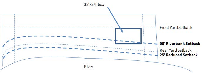
Diagram depicting lot set-back relief. All other required dimensional setbacks for the respective zoning district, in the absence of a variance or a special exception, as the case may be, shall be met.
410.8 Applications to Board of Adjustment.
- A. In any appeal to the Board of Adjustment from a determination of the district boundary under this section, the Board of Adjustment may require the owner of the land in question, or such owner's representative, to submit a map produced by a water resource professional depicting the ordinary high water mark, and any additional information the Board reasonably requires in order to reach a decision.
- B. Interested Parties: The Lebanon Conservation Commission is hereby determined to be an interested party to any Board of Adjustment proceeding under this section. Upon receipt of an application, the Board of Adjustment shall immediately forward a copy of the complete application to the Conservation Commission. The Conservation Commission shall receive notice of all proceedings of the Board of Adjustment, and the Board of Adjustment shall give due weight to all evidence submitted to it by the Conservation Commission.
Section 411 Pattern Zones Overlay District.
411.1 Purpose.
The purpose of the Pattern Zone Overlay District is to create additional housing that fits the character of the existing neighborhood in Downtown Lebanon and Downtown West Lebanon, to establish and preserve the characteristics of the historical downtown areas of Lebanon and West Lebanon, and to increase density and housing choices in the district.
411.2 Description of Pattern Zones Overlay District.
The areas and boundaries of the Pattern Zone Overlay District are shown on the Pattern Zone Overlay District Map of the City of Lebanon and made a part of this Ordinance and the Official Zoning Map of the City of Lebanon. The Pattern Zone Overlay District Map is attached hereto as Appendix D.
411.3 Permitted Uses.
The Overlay District regulations are intended to only be used for uses allowed within the Pattern Zone Overlay District Table of Uses. Any nonresidential uses shall adhere to regulations set forth in Article III based on the underlying zoning district.
| Permitted Uses | Special Exception |
|---|---|
|
Residential:
Commercial/Non-Residential
|
Residential:
Commercial/Non-Residential:
Conditional Use Permit Residential:
|
411.4 Table of Areas, Dimensions, and Coverage.
| Minimum Lot Requirements | Maximum Limitations | |||||
|---|---|---|---|---|---|---|
| Area | Frontage | Front Yard | Side Yard/Corner Side Yard | Rear Yard | Lot Coverage % of impervious cover | Height |
| 4,000 sq. ft. | 40' on lot that abuts a street* 15' on a flag shaped lot* 0' if on rear split lot* *Pursuant to 411.6 |
10' OR pursuant to 411.11 Front Yard | 5' / 7.5' | 10' | 60% by right 60% - 80% by Special Exception pursuant to 411.8 |
45' |
411.5 Parking.
A minimum of one on-site parking space per dwelling unit is required.
411.6 Creating New Lots in the Overlay District.
- A. Notwithstanding underlying zoning districts, new lots within the overlay may be created utilizing the overlay lot dimensional requirements.
- B. Creating a flag lot split shall provide 15' of frontage and meet the minimum lot area requirements.
- 1. Front yard setback requirements shall begin at the point where the lot widens.
- C. The creation of a rear lot without the street frontage required by RSA 674:41 may only be approved if all of the following conditions are met:
- 1. A perpetual deeded easement in favor of the rear lot to use a driveway across a lot which does have legally-sufficient frontage and identifying maintenance responsibilities shall be submitted with the application for approval by the Planning Board. If the subdivision is approved, the execution and recording of the easement in the registry of deeds shall be a condition of approval.
- 2. The driveway shall be shown on the subdivision plan.
- 3. The Planning Board shall determine that the driveway is sufficient for access to the rear lot.
411.7 Shading and Buffers.
- A. Preservation of a property's existing trees is encouraged to maintain a natural shade canopy upon the property.
- B. Properties shall be landscaped to achieve a minimum of 30% shade coverage.
- C. New houses located with the minimum 5' side yard setback from a property line must have a vegetative buffer.
411.8 Impervious Cover.
- A. Within the overlay district, impervious cover shall be limited as follows:
- 1. The maximum impervious cover shall be up to 60% by right.
- 2. Maximum impervious cover up to 80% may be permitted by Special Exception pursuant to Section 801.3.
- 3. For purposes of this overlay district impervious cover shall be defined as: A structure or land surface with a low capacity for infiltration, including but not limited to pavement, roofs, roadways, and compacted soils, that has a Curve Number of 98 or greater.
- 4. Impervious cover determinations when in question shall be made by the City Engineer.
- B. An applicant for a Special Exception to allow impervious cover up to 80% shall meet the criteria of Section 801.3 in addition to the following:
- 1. A stormwater management plan shall be provided to the Board. The plan must demonstrate that all stormwater is managed and treated onsite with a preference for low impact development stormwater management methods. Applicants may tie into the City's stormwater drain system as may be permitted by the City Code.
411.9 Snow, Garbage, Fuel Tanks.
- A. A snow storage plan shall be submitted with the application and, if approved, shall be a condition of the approval.
- B. Garbage/recycling receptacle storage plan shall be submitted with the application and, if approved, shall be a condition of approval.
- 1. Garbage/recycling shall not be stored in the front yard of the property.
- 2. Applicable screening shall be provided.
- 3. If a dumpster is used then it shall be enclosed, stored on a hard surface and meet screening requirements. A dumpster shall meet setback requirements, not interfere with parking, be located in the rear or side yard and beyond the front line of the structure and meet the setback requirements.
- C. Exterior fuel storage within the overlay shall:
- 1. Meet all zoning setback requirements.
- 2. Fuel storage tanks shall be located within the side or rear yard.
- 3. Underground fuel storage may be located in the front, side or rear yard provided they meet the required yard setbacks.
- 4. Above ground fuel tanks may not be located in the front yard.
411.10 Design Requirements.
- A. Design characterizes make sure any new development matches the existing neighborhood. The following requirements should be followed:
- a. Site changes, such as buildings, driveways, and other new features must not alter the historic character of a neighborhood;
- b. The location of new construction must be considered carefully in order to follow height and setbacks of existing buildings in the neighborhood;
- c. New construction must not destroy character-defining attributes or features of the neighborhood;
- d. New construction mush match the scale, size, massing and architectural features of existing buildings in the neighborhood;
- e. The relationship between the new construction and existing structures must be protected. Existing buildings must not be isolated from one another by new construction.
- f. Garages must be located at least 5' behind the front line of the residential structure;
- g. The applicant must provide evidence that their design matches the character of other residential structures on the street;
- h. Common Characteristics Found in the Overlay District:
- i. Pitched roof
- ii. Street-facing primary entrance
- iii. Front porch or stoop
- iv. Non-split level designs
- v. Clapboard, woodlap, vinyl, and/or shingle siding, stone, and/or brick exteriors in material and/or appearance
- B. Review of Projects
- 1. Using Pre-Approved Plan Sets
An Applicant may use architectural plans in the "Plan Book" free of charge but is required to apply for building permits, submit a site plan, and other materials as required by the Zoning Official and the Building Official.
- 2. Projects Requiring A Special Exception or CUP
Those residential projects requiring a Special Exception or CUP (Sect 411.3) will have to submit architectural drawings, designed by and stamped by a licensed New Hampshire design professional to be reviewed by the Heritage Commission pursuant to Section 408.7. The Heritage Commission will use the criteria listed in Section 411.10.A to determine the appropriateness of the design and issue a written recommendation to the Zoning Board or Planning Board for their consideration of the Special Exception or Conditional Use Permit.
- 3. If a property owner wishes to use an architecturally designed and stamped plan set not listed in the plan book for a permitted use then Heritage Commission approval and a Special Exception from the Zoning Board of Appeals is required. The architecturally designed and stamped plan set and site plan shall be reviewed and deemed in compliance with Section 411.10 Design Requirements by the Heritage Commission. The Heritage Commission shall issue a written recommendation to the Zoning Board who shall consider the plan set and site plan for a Special Exception.
- 1. Using Pre-Approved Plan Sets
411.11 Front Yard.
- A. The required front yard may be reduced to the average front yard of the existing buildings on the same side of the street in the same block and located within 300 feet of the subject lot, provided that there are at least 2 such buildings. This reduction shall not be allowed for lots fronting on a state highway.
- B. On lots with more than one frontage on an indeterminate lot, the front yard will be determined by the Zoning Administrator based on the orientation of the principal structure on the lot. The corner side with frontage will be considered a side yard and have a setback that is the average of the established front and side setbacks).
- C. On lots with no frontage, the front yard is determined by the Building Official or Zoning Administrator based on the orientation of the principal structure on the lot and the access easement location.
411.12 Approved Designs.
- A. The Heritage Commission shall maintain a book of architecturally designed pre-approved plans available for use by the people of Lebanon. Use of a pre-approved plan set shall qualify for the enhanced zoning considerations under the pattern zones overlay district.
- B. Prerequisite to being listed as a preapproved plan a plan shall be:
- a. Approved by the Heritage Commission.
- b. Reviewed by and deemed compliant with New Hampshire State Building Code requirements by the Chief Building Official.
- c. Designed by and stamped by a New Hampshire licensed design professional.
- C. Submittal of Design for the Plan Book
- a. A design professional wishing to nominate a design for the plan book:
- i. Prior to submission to the Heritage commission, submit a complete stamped plan set for administrative review with Planning Department Staff and the Chief Building Official and schedule a meeting to review the plans and discuss it compliance with the design criteria and the building code.
- ii. Following administrative review, submit a complete stamped plan set, with amendments as required by the administrative review, to the Heritage Commission for the Commissions consideration.
- b. The Heritage Commission will use criterial listed in Section 411.10.A. to make a determination if the plan should be included in the Plan Book.
- c. The Chief Building Official shall review the Heritage Commission approved plans for Building Code compliance and attach notes to the plans as needed to deem it approved.
- a. A design professional wishing to nominate a design for the plan book: